Open grid data has a huge public benefit
First Posted: 2026.04.23, Last Revised: 2026.04.23, Author: Tom Brown
Concerns have been raised about the security threat from sharing open grid data. I lay out the arguments why, for certain types of data, we should not be concerned. There is in fact a huge benefit from sharing this data, including for security. The security of our grid is extremely important, especially as we electrify more of our demand, so I end with measures that can actually help raise security and resilience.
In bullet points:
- Public benefit: Sharing data about clearly visible power lines and substation locations has many benefits for the public: planners can assess where the grid needs reinforcement to integrate renewables, electrification and for climate adaptation; market actors can get transparent information on grid constraints; new generators, storage and consumers can see where they can connect; companies with products that enhance grid capacity can assess their innovative technologies; researchers can test measures to improve market design and resilience; data is available for disaster response; and society can monitor the natural grid monopolies in order to keep grid costs down. Many examples of these benefits are listed below.
- No security threat: There is no danger to being open about visible infrastructure, because, well, it's visible. Pylons can be seen by anyone from the ground; substations are large enough that you cannot miss them. Much of this data (particularly substations) is already on regular maps, and all of it shows up in widely-available satellite data. Some governments have shared this data for decades. Anyone attacking this infrastructure will be capable of the minimal effort to obtain this information. State actors will have much better data sources.
- Reductio ad absurdam: Similar arguments could also be made about road maps. "Let's ban road maps so that our adversaries won't be able to find their way around!" It's clear in this case: i) the maps are already available; ii) even if they were banned today, there are many old maps around; iii) they can be reproduced from satellite imagery; iv) there is a high benefit to the public from road maps.
- Some data should not be shared: There is no public benefit to sharing information on security protocols, software versions, locations of security cameras, or the exact pathways of underground cables and pipelines. This data would help our adversaries and should remain private.
- Real security is not achieved by obscurity, i.e. hoping that your adversary cannot access satellite data or see the infrastructure from the ground. Real security requires layered defence measures that slow down adversaries, redundancies that can reroute power in case of damage, and regular threat assessments. The ability to recover quickly from outages requires good public knowledge about our public infrastructure.
I go into more detail on some points below.
Table of Contents
- 1. What is open grid data?
- 2. What open data is currently available for the grid?
- 3. Who is concerned about open grid data?
- 4. What examples are there of the public benefit of open grid data?
- 5. Did open data play a role in the partial blackout in Berlin in January 2026?
- 6. Could open data allow attackers to model power flow through the network?
- 7. Is it even feasible to ban open grid data?
- 8. What would provide real security and resilience?
- 9. How can open grid data improve security and resilience?
1. What is open grid data?
Open grid data is data about the grid that is available under an open licence. Open licences allow users to read, download, modify and reshare the data.
2. What open data is currently available for the grid?
Typically data is available for the transmission grid and the higher voltages of the distribution grid.
The Open Infrastructure Map shows the power lines and substations in OpenStreetMap for the whole world. OpenStreetMap data is entered by public-spirited mapping enthusiastics around the world. OpenStreetMap only maps visible infrastructure above ground. Initiatives like MapYourGrid empower people to improve open grid mapping, especially in regions that currently are not so well covered. Please support these initiatives!
The data on the power lines and substations is processed into grid models for use in open energy system models like PyPSA-Eur, PyPSA-Earth or Euro-Calliope. Xiong et al, 2025 provides more detail on this for PyPSA-Eur.
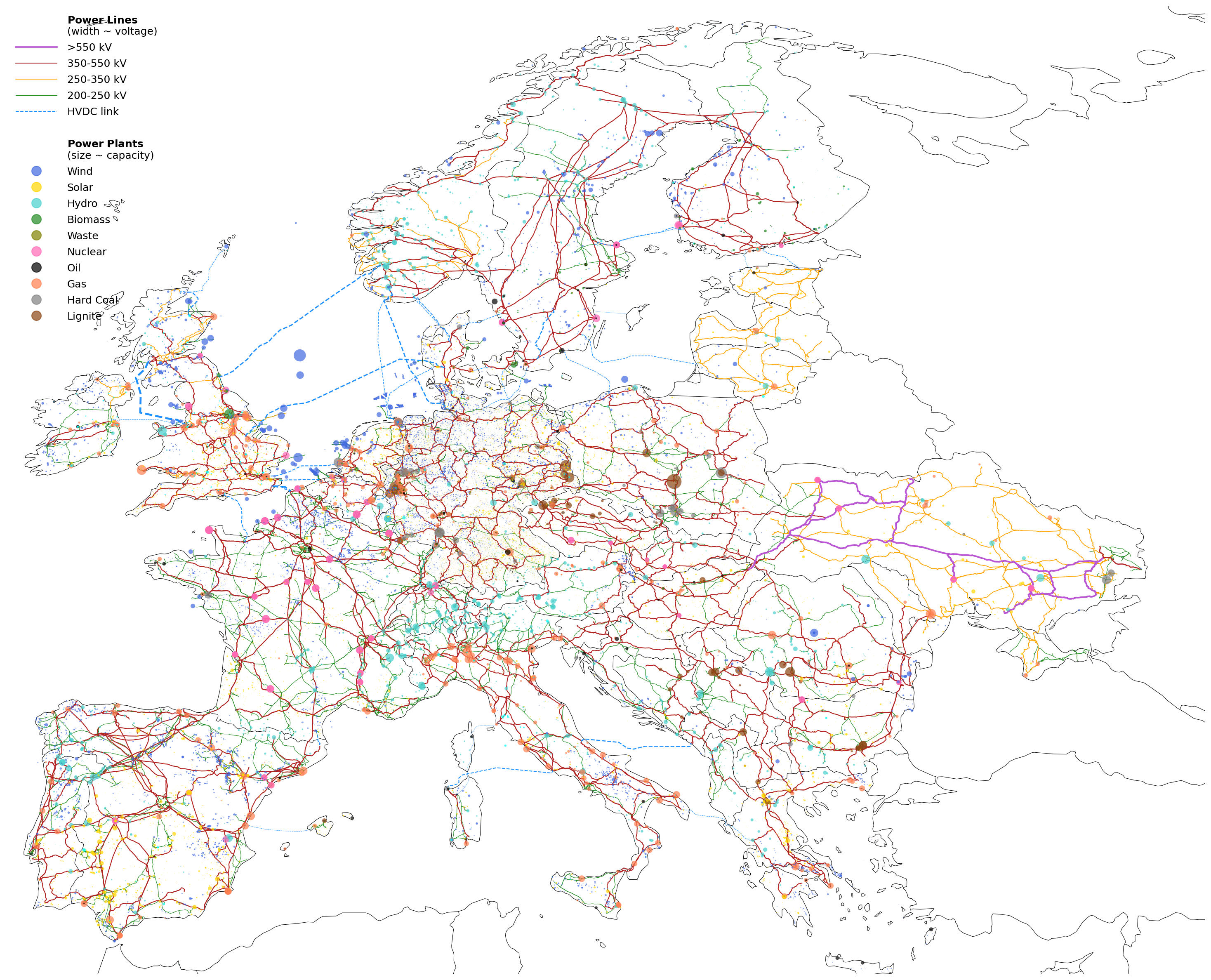
Figure 1: European model PyPSA-Eur
It is also used by many other actors, such as renewable energy developers, storage developers and new industrial consumers like data centres, who are all looking for connection points to the grid. The data is available in high quality and in a uniform quality across the globe.
3. Who is concerned about open grid data?
The chancellor of Germany, Friedrich Merz, said in January 2026 that information about critical infrastructure should no longer be openly available. German industry associations have also raised concerns about transparency requirements in the KRITIS law.
These statements are mixing concerns about visible infrastructure, which do not pose any security threat, and more sensitive data (such as software versions, security protocols, maps of non-visible infrastructure) that would endanger security if released.
4. What examples are there of the public benefit of open grid data?
These are a few examples that jumped to mind - please email me if you want your example added to the list.
- The European Commission's Joint Research Centre (JRC) used the open grid model PyPSA-Eur in 2024 for a study on redispatch and congestion management that was highlighted in the 2024 Draghi Report as an example of why a more efficient market design is needed. Significant reductions to redispatch volumes and renewable curtailment were found with more grid expansion.
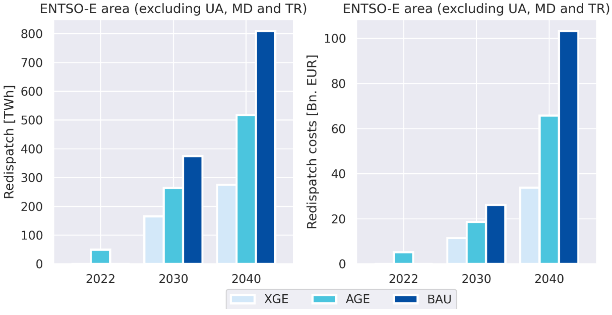
Figure 2: Redispatch evolution with extreme grid expansion (XGE), advanced (AGE) and business-as-usual (BAU), using open grid data (Source: JRC, 2024)
- The same research team at JRC used the same model in a 2025 report on the benefits of local price signals in Europe.
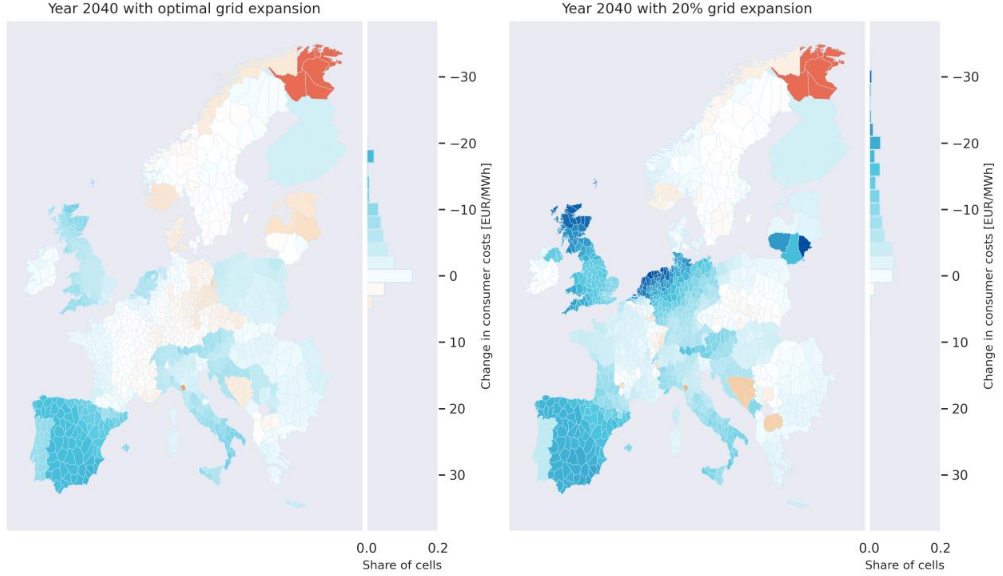
Figure 3: Cost savings for end consumers with locational pricing in Europe using open grid data (Source: JRC, 2024)
- The open grid model PyPSA-Eur was used in 2021 by researchers to show the benefits of grid expansion.
- The open grid model PyPSA-Eur was used in 2023 by researchers to show the benefits of dynamic line rating (DLR), an example of a Grid Enhancing Technology (GET).
- The firm dvlp.energy uses open grid data to help developers find land for their solar, wind or storage projects.
- European electricity market participants need grid data to assess the grid capacity available for market trading in the Flow-Based Market Coupling.
- A 2023 IEEE power & energy magazine article Grid Planning for Electrification Using Highly Granular Analytics: Insights Into the Transportation Distribution Infrastructure points out that "Publicly available grid data can significantly aid quick and effective scenario analysis, helping to determine where and when capacity issues will arise and how different kinds of DERs can contribute toward the management of the system" (full magazine is available).
- OpenStreetMap data is used to assess Data Centre Siting in Europe.
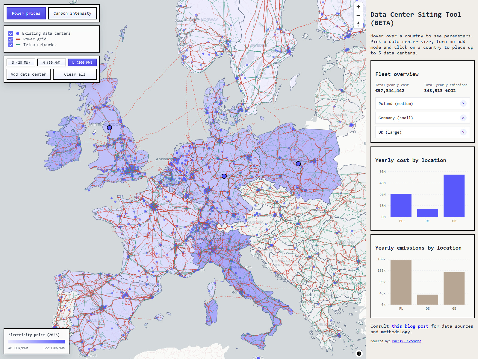
Figure 4: Data Center Siting Tool (Source: Paul Czyzak, 2026)
- The Global Electrification Platform, Distributed Renewable Energy Atlas and REZoning tool, developed and used by the World Bank, use open grid data from OpenStreetMap to support rural electrification planning across 58 countries. GEP-OnSSET, the Open Source Software behind Global Electrification Platform, relies heavily on electrical grid data of OpenStreetMap.
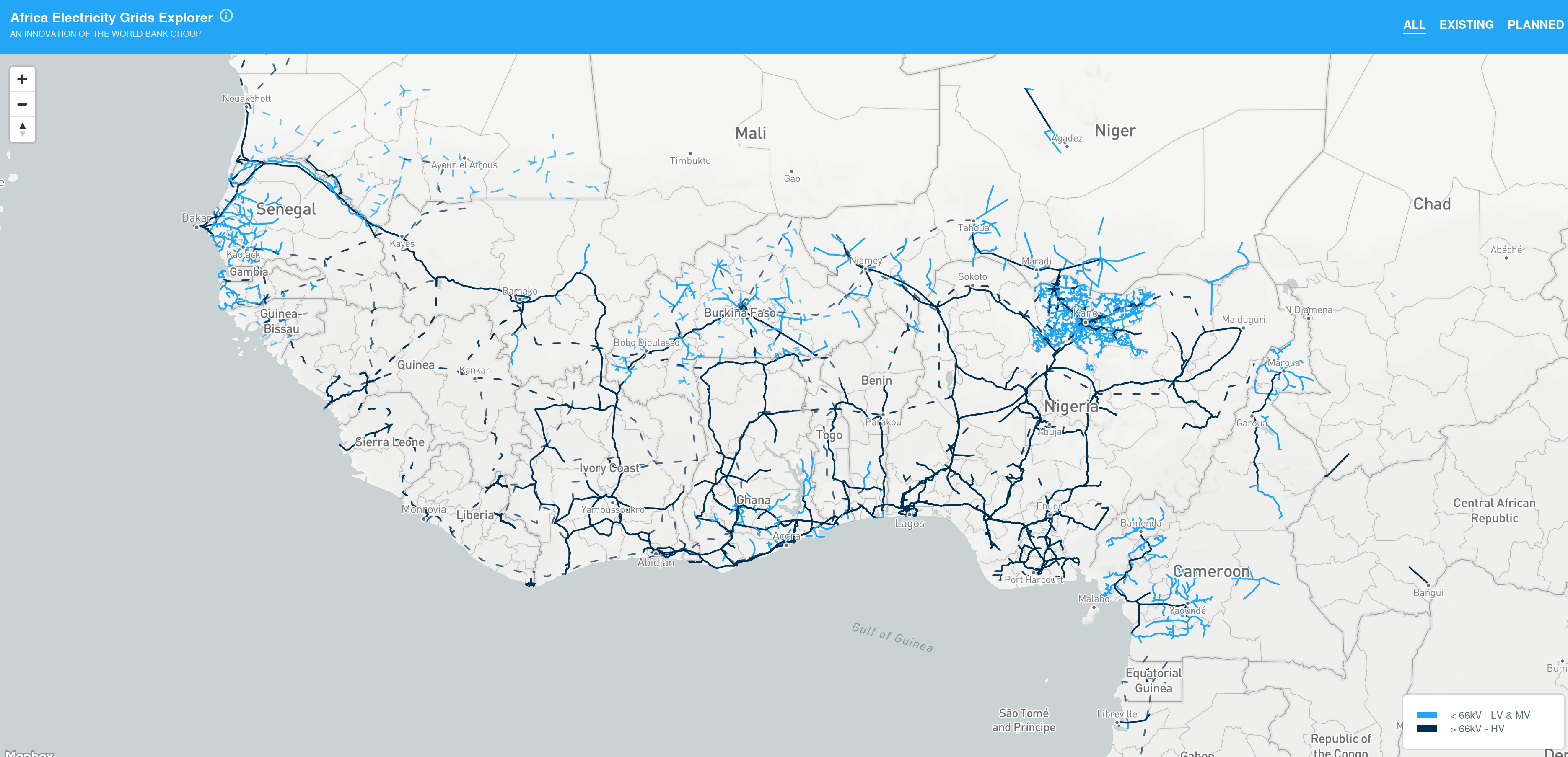
Figure 5: Zoom on World Bank's Africa Electricity Grids Explorer, used for initiatives in grid and off-grid electricity access, grid infrastructure upgrading, renewable energy and sector planning (Source: Africa Electricity Grids Explorer, 2026)
- The Humanitarian OpenStreetMap Team provides high-quality, open geospatial data to guide decision-makers during early disaster response, including open grid data.
- The Energy Access Explorer is the first open-source, online, interactive geospatial platform enabling energy planners, clean energy entrepreneurs, donors and development institutions to identify areas of high priority for energy access interventions. it uses OpenStreetMap grid data.
- The Energy Planning Group Library offers a range of tools and models created by the World Bank's Energy Sector Management Assistance Programme (ESMAP) to support the planning of electricity systems at more than 40 national and regional levels. Studies performed using this framework primarily utilise OpenStreetMap's transmission grid data.
- The French utility company Enedis, operating the electricity distribution network, mapped power poles and substations with the help of a strong local OpenStreetMap community.
- The Swiss company Gilytics uses OpenStreetMap grid data for infrastructure planning.
- The ETAP software can directly use OpenstreetMap data.
Many of these examples and more can be found on the MapYourGrid Impact page.
5. Did open data play a role in the partial blackout in Berlin in January 2026?
In January 2026 arsonists attacked a cable bridge in Berlin resulting in multi-day power outages for thousands of households.
The cable bridge is visible on the Open Infrastructure Map but it is also visible from the path along the canal as well as in satellite imagery. Open data did not contribute to the security threat.
It turns out the bridge was barely protected at all, with gaps in the fence and minimal monitoring (Spiegel paywall, RBB no paywall).
Below we lay out measures that would have improved security in cases like this.
6. Could open data allow attackers to model power flow through the network?
Open grid data is good enough for a rough assessment of power flows through the network, which would assist planners and market participants. However, since information on outages, switching and other operational details are missing, it is not sufficient for the detailed power flow modelling that would be helpful to adversaries.
7. Is it even feasible to ban open grid data?
OpenStreetMap grid data is already backed up in thousands if not millions of locations worldwide. Satellite imagery that includes grid infrastructure is similarly widely available. Trying to restrict access or sharing of this data does not seem to be feasible. Even if one jurisdiction bans the sharing of open grid data, others will continue to host it.
8. What would provide real security and resilience?
This is a question for real security experts, but I can provide a few thoughts.
An important security maxim is "design your system assuming that your opponents know it in detail" (Kerckhoffs's principle or Shannon's maxim). That means: protecting the vulnerable parts and ensuring redundancy where possible.
Protecting the vulnerable parts means setting up layered barriers to slow down attackers and lower probabilities, knowing that 100% security everywhere is impossible against determined attackers.
Redundancy means that if one network component fails, power can redistribute to other parts of the network (contingency analysis).
Examples of improving security include (oriented towards the Berlin cable arson attack describe above):
- Better fence protection at vulnerable points. Fencing will not stop determined attackers, but it slows them down until police can arrive.
- Cameras with AI watching to alert police if anyone crosses or attacks fences. Cameras can be destroyed, but they provide early warning and another security layer.
- Avoid multiple cables bundled in the same place where possible.
- Have redundancies to supply medium voltage networks from more directions, e.g. from neighbouring network.
- Stockpile mobile power plants to supply critical loads in an emergency that can be deployed within 2-6 hours.
- Stockpile replacement grid equipment so that repairs can be effected quickly.
- Flexibility from storage and demand-side management to work around grid outages.
- Allow regions of the network to function independently for grid restoration after emergencies.
- Regular threat assessments and updates to protocols.
9. How can open grid data improve security and resilience?
By making grid data available a wide range of stakeholders can provide feedback on how to improve security, pooling know-how from different domains. For example, planners, researchers and emergency services can explore the data to plan better for outages.
Open grid data also helps emergency services to react in the case of disasters.
An example: The US Department of Homeland Security (DHS) made available Homeland Infrastructure Foundation-Level Data (HIFLD), "high-quality geospatial data and tools for planners, analysts, and others" with the explicit goal to support "law enforcement, border protection, emergency management, critical infrastructure protection, and national operations and data fusion centers". This data was critical for coordinating crisis management after Hurricane Harvey hit in 2017.